ملف:LINE21.jpg
اذهب إلى التنقل
اذهب إلى البحث

حجم هذه المعاينة: 800 × 552 بكسل. الأبعاد الأخرى: 320 × 221 بكسل | 640 × 442 بكسل | 1٬000 × 690 بكسل.
الملف الأصلي (1٬000 × 690 بكسل حجم الملف: 102 كيلوبايت، نوع MIME: image/jpeg)
ملخص
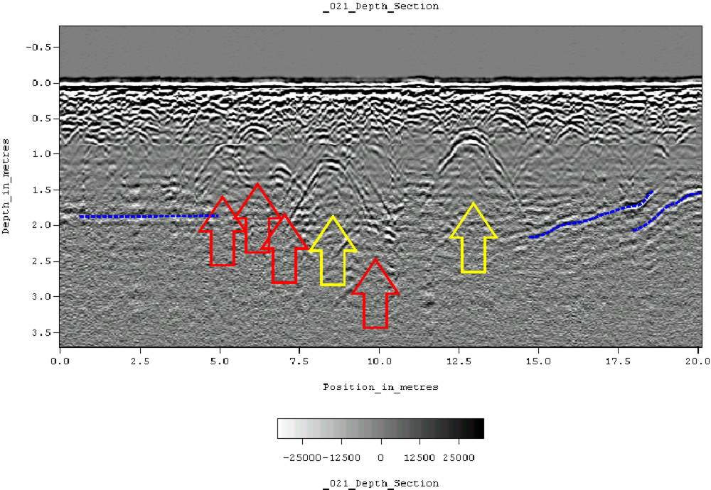
| الوصف | Ground-penetrating radar depth section (profile) collected on an historic cemetery in Alabama, USA. Yellow arrows indicate very distinct reflections, probably associated with human burials. "hyperbolic" reflections, appearing as an inverted U, are typically associated with discrete objects. Less distinct hyperbolic reflections are indicated by red arrows. dashed blue lines indicate horizontal and sloping reflectors, probably bedrock. The many smaller reflections near the surface are likely to be caused by tree roots. Because of the nature of the site, subsurface testing was not conducted, but these interpretations are supported by surface indications (grave markers and depressions) and with line-to-line patterning within the GPR data. |
| التاريخ | ١١ يونيو ٢٠٠٧ (تاريخ الرفع الأصيل) |
| المصدر | نُقِلت من en.wikipedia إلى كُومُنز . |
| المؤلف | Tapatio في ويكيبيديا الإنجليزية |
ترخيص
| وضع -Tapatio في ويكيبيديا الإنجليزية-، وهو المؤلف، هذا العمل في النِّطاق العامِّ. يسري ذلك في كل أرجاء العالم. في بعض البلدان، قد يكون هذا التَّرخيص غيرَ مُمكنٍ قانونيَّاً، في هذه الحالة: يمنح Tapatio الجميع حق استخدام هذا العمل لأي غرض دون أي شرط ما لم يفرض القانون شروطًا إضافية. |
سجلُّ الرَّفع الأصيل
صفحة الوصف الأصلية كانت هنا، تشير جميع أسماء المستخدمين التالية إلى en.wikipedia.
- 2007-06-11 05:16 Tapatio 1000×690×8 (104839 bytes) {{PD-self}}
- 2007-06-11 04:49 Tapatio 1000×690×8 (104839 bytes) Ground-penetrating radar depth section (profile) collected on an historic cemetery in Alabama, USA. Yellow arrows indicate very distinct reflections, probably associated with human burials. "Parabolic" reflections, appearing as an inverted U, are typicall
تاريخ الملف
اضغط على زمن/تاريخ لرؤية الملف كما بدا في هذا الزمن.
| زمن/تاريخ | صورة مصغرة | الأبعاد | مستخدم | تعليق | |
|---|---|---|---|---|---|
| حالي | 19:02، 17 أكتوبر 2007 | | 1٬000 × 690 (102 كيلوبايت) | wikimediacommons>Conscious | full resolution |
استخدام الملف
الصفحة التالية تستخدم هذا الملف: